Saturday, 12 September 2015

Canoeing the Thames


The White Swan, Twickenham

Over a few weekends and weekdays, my friend Bill and I canoed the River Thames from the Cotswolds to London. The river runs for 170 miles (275km) from its source near Kemble to our destination at the Greenwich MeridianIt actually took us 5 years overall to finish all the legs (from 2008 to 2013), in part due to Bill and I living in different continents! 

It was a great adventure, we saw some lovely countryside along the way plus small towns and villages that I would otherwise probably never have visited. The river also passes through the large towns/cities of Oxford, Windsor and London. We met lots of friendly boaters, walkers, lock keepers and inn keepers along the way!


I am posting all the information we used which might be helpful to anyone else planning a similar trip. The links on the right of this page sets out our individual legs, and detailed information including a spreadsheet and GPS waypoints to download can be found at the bottom of this page.

We didn’t do the legs in order, but I have listed them in sequence from source to Greenwich to make it easy to follow. We took a fairly leisurely journey but it would definitely be possible to combine some of the legs, particularly in a faster canoe and with earlier starts; we were usually only on the water by 11am!
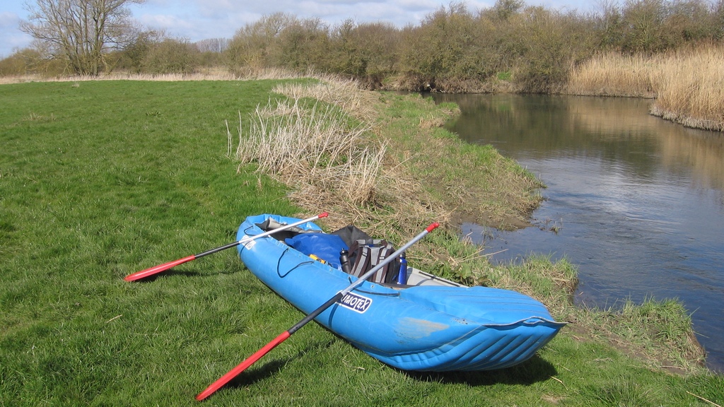

Our basic gear:

Canoe: We used a Gumotex Palava inflatable touring canoe (nicknamed ‘Gorgeous George’). It packs down into a backpack weighing about 25kg so it was easy to break our trip into legs and use public transport and taxis. It is hard wearing and has survived having a fishing hook in it and being dragged along stony river beds. I wish I had £1 for each time we were asked 'Is that inflatable?'!

Buoyancy Vests: The upper reaches of the river are fairly leisurely, but there were parts where the entire width of the river was blocked by fallen trees ("strainers"). Further downstream there are strong tides, boat traffic and locks to contend with, so a buoyancy vest is recommended.

Thames Licence: A licence is needed for paddling on the Thames above Teddington Lock. It is available from the Environment Agency, can be purchased from lock keepers or is included in British Canoeing membership. The Port of London Authority (PLA) is responsible for the Thames after Teddington Lock and no licence is required.

GPS: I loaded GPS waypoints onto a Garmin 60 so we knew our speed and the distance to the next geographical feature and our destination for the day (see the 'Detailed Information' section below to download my GPS waypoints). These can also be used in Google Maps on a smartphone.

Food & drink: There are some stretches with limited amenities, so for some legs we had to be self sufficient. Our preferred provisioner was Marks & Spencer, particularly their highly calorific 'Chocolate Refrigerator Squares'! 

Camping gear: We camped on a few occasions, so either took all of our gear with us (which made for a very heavy canoe – not ideal for carrying through portages) or parked our car at the campsite early in the day and left our camping gear there before taking a taxi to our starting point and returning by canoe that evening.

Detailed Information:

I have put together the following information which you can download for free from this link:

Download Link 

1) an Excel spreadsheet which sets out the bridges, locks, points of interest, pubs, campsites etc from the source all the way to Greenwich, including mileage distances between these features to help you plan your journey.

2) GPS waypoints from the source to Windsor, showing bridges, locks, points of interest etc. This is in KMZ format for use in Google Maps on a smartphone or on a handheld GPS for you to track your progress as you go.

3) GPS waypoints for all London Riverside Pubs from Walton right into central London. This is also in KMZ format for use in Google Maps on a smartphone or on a handheld GPS.


Further Reading/Viewing:

Port of London Authority Information:
There is useful safety information and guidance for canoeists on the PLA website. 

General Thames Information:
There is information on places to eat and stay on the Visit Thames website.

General Canoeing Information:
There is lots of information on canoeing, rivers and licences on the Go Paddling website.

The classic 1889 book "Three Men in a Boat" by Jerome K Jerome. A story of a trip up the Thames from Kingston to Oxford.

The BBC TV series "Three Men in a Boat" featuring Dara O'Briain, Rory McGrath and Griff Rhys Jones which followed Jerome K Jerome's trip.

The book "Pub Paddles" by Peter Knowles with ideas for canoe pub trips in the south of England, including on the Thames.

"The River Thames Book" by Chris-Cove Smith, which has detailed information on travelling on the non-tidal Thames (plus the River Wey which is another lovely paddle).

We used extracts from Ordnance Survey maps but the Imray publication "Map of The River Thames" might be a good alternative.
 

Thursday, 10 September 2015

Leg 1 – From the source to Lechlade (overnight in Cricklade)


The Thames Head Inn, close to the source of the river

Leg Distance: 22 miles (of which 11 miles was on foot)

Number of Locks: 0

Time Taken: 2 days

Overnight Accommodation: The Old Bear, Cricklade SN6 6AA

Overall Distance Covered: 22 miles (2 days)


We left our car (and canoe) at our overnight accommodation and took a taxi to The Thames Head Inn, not far from the source of the Thames. 

First pint to mark the start of the trip

After a pint at the pub to send us on our way we walked to the source, where there is a marker stone with the following inscription:

THE CONSERVATORS OF THE RIVER THAMES
1857-1954
THIS STONE WAS PLACED HERE TO MARK THE
SOURCE OF THE RIVER THAMES 


Path towards the source of the Thames

There was no sign of any water at this point and we had to walk further on across the A433 road until we found a trickle of water coming out of the ground. It was amazing to think that over our journey we would see this transform into the large river that flows through London.

The early stages of the river


We followed the trickle until it became a stream, then a river and carried on to Ewen, where we had lunch at The Wild Duck Inn. After that we continued past the Cotswold lakes and on to Cricklade.  

The river running through Ashton Keynes village
 
We checked into our accommodation at The Old Bear pub and had a few well deserved drinks followed by a curry at The Ancient Raj. There was a 6 nations rugby match on (Wales v Ireland) so we watched some of that over drinks at The White Lion Inn and The Red Lion Inn.

The next day we put the canoe in to the water on Abingdon Court Lane which, due to low water levels, was as close to Cricklade Town Bridge as we could start canoeing. With the exception of one or two ferocious swans guarding their cygnets we had a lovely paddle to Lechlade through beautiful countryside. We met quite a few walkers along the way who were intrigued by our plans (and our inflatable canoe!).

Quiet upper stretch of the Thames by Water Eaton foot bridge

The early stretches of the river were quite shallow and we ran aground a few times, so had to get out and wade to deeper water. As we canoed this section early in the year few other canoes had been out and so there were some blockages from fallen trees that had yet to be cleared. One large tree blocked the entire width of the river under Water Eaton foot bridge, so we had to divert around it. We took an early lunch stop at the Red Lion pub in Castle Eaton, leaving our canoe on the opposite bank.

Upon reaching Lechlade we got out using the grounds of the New Inn Hotel, and then took a taxi back to Cricklade to collect the car.

If you would like to download detailed information on the river please see this blog entry.

Wednesday, 9 September 2015

Leg 2 – Lechlade to Eynsham (overnight at Rushey Lock)


Loading our camping gear at Rushey Lock

Leg Distance: 24 miles

Number of Locks: 9

Time Taken: 2 days

Overnight Accommodation: Camped at Rushey Lock, Buckland Marsh

Overall Distance Covered: 46 miles (4 days)


We parked in Lechlade and put the canoe in using the grounds of the New Inn Hotel. We took all of our camping gear with us, so the canoe was very heavily laden which made portage around the locks tough and so paddled through the locks whenever possible, which the lock keepers seemed very happy with.

Radcot Bridge

We were self sufficient for lunch and dinner and set up camp that night at Rushey Lock. It is an official campsite with a toilet/shower block. The camping fee is paid to the lock keeper.

We went to have a look at The Trout at Tadpole Bridge, but it looked more like a restaurant than a pub so we decided not to have drinks there and headed back to the lock to set up our stove and disposable BBQ for dinner by the river.

Meeting other boaters at Rushey Lock
 
The following day we stopped for lunch at the Rose Revived pub at Newbridge – we pulled our canoe onto the steep bank on the left just after the bridge. There is an alternative pub, The Maybush, on the right hand side before the bridge which has an easier get out point, but that pub didn't look as appealing.

Going through Pinkhill Lock

We got out at Eynsham Lock and took a taxi over Swinford Toll Bridge back to our car at Lechlade.

If you would like to download detailed information on the river please see this blog entry.

Tuesday, 8 September 2015

Leg 3 – Eynsham to Abingdon (overnight in Oxford)


The Head of The River pub, Oxford

Leg Distance: 15 miles (plus 5 mile trip up the River Cherwell)

Number of Locks: 6

Time Taken: 2 days

Overnight Accommodation: Oxford Sea Scouts Building, Oxford OX4 4BJ

Overall Distance Covered: 61 miles (not including River Cherwell) (6 days)


We parked the car at the Oxford Sea Scouts building and then took a taxi to Eynsham Lock. We canoed to Port Meadow, just before Oxford, where we met up with Bill’s aunt Ruth, cousin Karen and family and had a picnic lunch with them.

The ruins of Godstow Nunnery, beside Godstow Lock
After lunch (& after Bill had taken a swim across the river and back) our convoy of 2 canoes and 3 kayaks paddled into Oxford and then took a 5 mile round trip on the River Cherwell - we spotted a man fishing for crayfish, there were a lot of them as he had already collected a bucketful! 
 
Avoiding punts on the River Cherwell by Magdalen Bridge

We went for a drink at The Cherwell Boathouse; the others were going to have dinner there so Bill and I paddled back to the Thames to our accommodation, close to Donnington Bridge.

Our overnight accommodation

As we were staying inside the Sea Scout building we didn’t need to put the tent up so we left the canoe and all our gear inside before heading into Oxford city centre for a tour of some well known pubs such as:


The following day we walked the mile or so back into Oxford city centre for some sightseeing. Oxford is really beautiful; we took a wander through the covered market, climbed to the top of the Sheldonian Theatre and visited Radcliffe Camera, Bridge of Sighs and New College.

New College, Oxford

New College, Oxford

After shopping for our lunch we walked back to the Sea Scouts building, past the university boathouses, packed our gear and then paddled down to Abingdon – the wind was against us so it was hard going, so at one point we pulled over for a picnic followed by a snooze in the afternoon sun!

Disaster with re-provisioning in Oxford!

Because of our late start after a morning sightseeing in Oxford we only made it as far as Abingdon Lock, so it was a reasonably short taxi ride back to our car in Oxford.

If you would like to download detailed information on the river please see this blog entry.

Monday, 7 September 2015

Leg 4 – Abingdon to Purley on Thames (overnight in Wallingford)

Our starting point at Abingdon Lock


Leg Distance: 27 miles

Number of Locks: 8

Time Taken: 2 days

Overnight Accommodation: Riverside Park Campsite, Wallingford OX10 8EB

Overall Distance Covered: 87 miles (8 days)


We parked our car at the campsite in Wallingford and then took a taxi to our starting point at Abingdon Lock.

The Shillingford Bridge Hotel was a nice stop for a drink a few miles before reaching Wallingford – we sat on the lawn whilst keeping the canoe from floating away.

Wallingford Bridge

The campsite was right by the river so was great for canoe access - it is located on the opposite side of the river from Wallingford town just across the medieval bridge (apparently famous for having 22 spans!).

Camping in Wallingford

Dinner was at Anokhi curry house in Wallingford, which was pretty good. Wallingford is a very nice market town, but on a Saturday night there were lots of people hanging around and it felt like something might kick off!

Portage access at Whitchurch Lock

The next day, after buying provisions for lunch at Waitrose in Wallingford, we paddled down to Mapledurham often trading places with the African Queen paddle boat on the way; we were quicker through the locks than them by using the portages.

We got out at a large grassed area at Purley on Thames, on the right hand side just after Mapledurham House. We arranged for a taxi to pick us up from Purley Park Social Club and take us back to our car at Wallingford.

If you would like to download detailed information on the river please see this blog entry.